
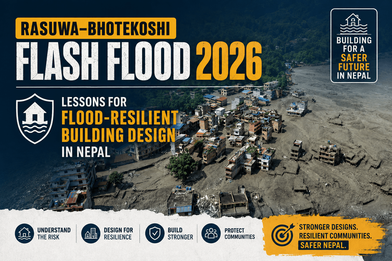
On August 26, 2026, a devastating flash flood swept through the Bhotekoshi river corridor in Rasuwa, affecting settlements and infrastructure from the Nepal–China border area downstream toward the Trishuli river system.
Timure and Syabrubesi were among the heavily affected areas, while flooding and damage were also reported farther downstream in Rasuwa, Nuwakot, Dhading and other locations along the river corridor. Roads, bridges, buildings, hydropower infrastructure and settlements were damaged as the sudden surge travelled downstream.
For Nepal, the Rasuwa flash flood is not only a disaster-response story. It raises a much broader question:
How should we plan, locate and design buildings in a country where rivers, steep terrain, landslides, extreme rainfall and glacial hazards can interact with human settlements?
No building can be made completely immune to every natural disaster. However, thoughtful site selection, risk assessment, architectural planning, engineering and drainage design can significantly improve resilience and reduce unnecessary exposure.
The Rasuwa–Bhotekoshi flood offers important lessons for anyone planning to buy land, design a house or develop property near rivers and steep terrain in Nepal.
What Happened in the Rasuwa–Bhotekoshi Flood?

The flood entered Nepal through the Bhotekoshi system from the Tibetan side on the morning of August 26 and moved downstream into the Trishuli river.
According to an initial technical assessment reported on August 27, authorities received information shortly after 9 a.m. that a major flood had entered the Bhotekoshi. The surge then progressed downstream through the Bhotekoshi and Trishuli rivers toward the Narayani river system.
The exact triggering mechanism continues to be investigated.
Preliminary assessments have suggested that an ice or rock avalanche may have blocked the Lhende river upstream, creating a temporary accumulation of water that later released suddenly. Satellite information examined by Nepalese authorities reportedly indicated a blockage roughly 20 kilometres upstream of the Miteri Bridge.
This distinction matters.
The August 2026 Rasuwa flood should not automatically be described as a confirmed glacial lake outburst flood (GLOF) until investigations establish the exact mechanism.
It should also not be confused with the July 8, 2025 Rasuwa flood, when Nepal's Department of Hydrology and Meteorology concluded that a glacial lake outburst in the Lhende river area had caused the sudden flooding.
For property owners and designers, however, both events demonstrate something important: river risk is not determined by local rainfall alone.
A building may experience dangerous flooding even when there is little or no rain directly above the site.
Why the Rasuwa Flood Matters for Architecture in Nepal

When people think about a safe building in Nepal, earthquake resistance often comes first.
That is understandable. Nepal is highly seismic, and earthquake-resistant construction is essential.
But resilient architecture has to consider multiple hazards simultaneously.
Depending on the location, those may include:
- earthquakes
- flooding
- flash floods
- riverbank erosion
- landslides
- debris flows
- unstable slopes
- extreme rainfall
- poor drainage
- soil instability
- access failure during emergencies
The Department of Urban Development and Building Construction publishes the Nepal National Building Code, covering architectural requirements, structural design, construction safety, plumbing and other aspects of safer building construction. Nepal has also been working to strengthen code compliance and disaster-resilient construction.
But compliance with a building code is only one part of the process.
A structurally strong building placed on a fundamentally unsafe site can still be highly vulnerable.
That is why good architecture begins before the first floor plan is drawn.
1. Site Selection Comes Before House Design
One of the biggest mistakes a property owner can make is choosing land based only on:
- price
- road access
- view
- orientation
- plot shape
- neighbourhood
- proximity to a river
without understanding the physical behaviour of the site.
Before designing a house near a river or steep terrain in Nepal, the project team should ask:
Where has the river flowed historically?
Is the site part of a floodplain or old river terrace?
How high is the land compared with the river channel?
Is there evidence of previous erosion or sediment deposition?
Is the plot below a steep or unstable slope?
Where does surface water travel during intense rainfall?
What happens if an upstream blockage suddenly releases water?
The cheapest plot is not necessarily the cheapest place to build.
A difficult site may require substantial spending on retaining structures, drainage, slope stabilization, access improvement or foundation work. More importantly, some hazards cannot be solved simply by spending more on the building.
Architecture lesson:
Do not design the house first and analyse the land later. Analyse the site first, then design the building around the site's opportunities and risks.
2. Distance From a River Is Not the Only Measure of Flood Safety
Property owners often ask:
“How far should my house be from the river?”
It is an important question, but distance alone cannot determine safety.
Two properties located the same distance from a river can have completely different risk profiles.
Factors include:
- difference in elevation
- width of the river valley
- shape of the river channel
- historical flood extent
- bank stability
- upstream catchment conditions
- bridges and other structures that may trap debris
- possibility of erosion
- local topography
- drainage paths
- landslide or debris-flow exposure
A property 100 metres from a river at a very low elevation could sometimes face greater flood exposure than a property closer to the river but located substantially higher on stable ground.
That is why site-specific flood and terrain assessment is much more valuable than relying on a single generic setback number.
Local laws, planning requirements and river setbacks must always be checked before construction.
3. Finished Floor Level Can Make a Major Difference
Where flood risk exists but development is legally and technically appropriate, one important design consideration is the finished floor level.
The main occupied floor should not automatically be placed at the lowest convenient level of the site.
Depending on the location and engineering assessment, designers may consider:
- raising occupied floors
- creating a higher plinth
- adjusting building levels to natural contours
- avoiding vulnerable basement spaces
- locating critical equipment above potential flood levels
This does not mean simply raising every house on columns.
The correct solution depends on water depth, flow velocity, soil condition, foundation requirements and local regulations.
Fast-moving floodwater behaves very differently from slowly rising water.
A flash flood carrying rocks, timber, vehicles and debris can exert enormous forces on a building.
Therefore, elevation must be combined with proper structural and geotechnical analysis.
4. Drainage Should Be Designed, Not Added Later
In many residential projects, drainage receives less attention than rooms, elevations and finishes.
That is a mistake.
Water can damage a property even without a major river flood.
During intense rainfall, poorly managed surface runoff can cause:
- water entering ground floors
- erosion around foundations
- retaining-wall pressure
- slope instability
- waterlogging
- damage to access roads
- dampness and deterioration
A good site plan should identify how water enters, moves across and leaves the property.
Roof water, courtyard runoff, road runoff and natural uphill drainage should not simply be allowed to collect around the building.
Good architectural planning works with civil and engineering considerations to provide appropriate:
- site grading
- stormwater drainage
- roof-water management
- drains and channels
- retaining-wall drainage
- safe discharge routes
Drainage should be part of the initial design—not something solved after construction begins.
5. Foundations Must Respond to the Ground, Not Just the Building
A beautiful floor plan cannot compensate for a poor understanding of the soil beneath it.
Near rivers, soil conditions can vary significantly.
Ground may contain:
- loose deposits
- sand
- gravel
- sediment
- filled land
- saturated soil
- erodible materials
Flooding can also cause scour, where flowing water removes soil around foundations, bridge supports or retaining structures.
For sites with significant geotechnical uncertainty, foundation decisions should be based on appropriate investigation and structural engineering rather than assumptions.
This is especially important for buildings near:
- riverbanks
- steep slopes
- filled ground
- previously eroded areas
- landslide-prone terrain
Architecture lesson:
Foundation design should respond to the actual ground conditions—not simply copy what was built on another property.
6. Retaining Walls Are Not a Complete Flood-Safety Solution
In Nepal's hilly settlements, retaining walls are common.
But a large retaining wall does not automatically make a difficult site safe.
Walls must deal with more than soil pressure.
Water accumulating behind a retaining wall can significantly increase pressure and contribute to failure.
Therefore retaining structures often require carefully designed:
- drainage
- weep holes
- filter materials
- foundations
- reinforcement
- erosion protection
A retaining wall should be designed as part of the site's overall engineering strategy.
It should not become a way to force construction onto land that should first be studied more carefully.
7. Avoid Blocking Natural Water Paths
Water follows gravity.
If a building, compound wall or filled platform is placed directly across an existing drainage route, water will still attempt to find a path downhill.
During extreme rainfall, what appears to be a small seasonal channel can carry a much larger volume of water.
Architects should therefore study:
- existing contours
- gullies
- seasonal streams
- neighbouring drainage
- uphill catchments
- road drainage
before finalizing the building footprint.
Sometimes the smartest design decision is not to fight a natural drainage corridor but to keep construction away from it.
8. A Safe Building Also Needs a Safe Way Out
Building resilience is not only about whether a structure remains standing.
People must also be able to escape.
The Rasuwa flood damaged roads and bridges, including large sections of the route connecting the border region with downstream areas.
This highlights the importance of considering access resilience when planning settlements, hotels, resorts, homes or commercial projects in remote and river-adjacent areas.
Questions should include:
- Is there more than one possible escape route?
- Can occupants quickly reach higher ground?
- Is the access road itself vulnerable to flooding or landslides?
- Could a bridge failure isolate the property?
- Where is the nearest safe assembly area?
A building may survive a disaster and still become dangerous if occupants cannot safely evacuate.
9. Critical Services Should Not Always Be at the Lowest Level
Property planning should also consider where critical systems are placed.
Depending on the site's assessed risk, it may be wise to avoid locating vulnerable equipment in the lowest part of a building.
Examples include:
- electrical panels
- backup power systems
- communication equipment
- pumps
- important documents
- building-control systems
The goal is to improve the building's ability to function or recover after an emergency.
For larger projects such as hotels, resorts, schools, institutions and commercial buildings, business continuity should form part of the resilience strategy.
10. Designing With Nepal's Landscape Instead of Against It
Nepal's mountains and river valleys create some of the most dramatic sites for architecture.
They also create complex design challenges.
A responsible design approach does not begin with:
“How large a building can we fit here?”
It begins with:
“What is this site telling us?”
The architecture should respond to:
- terrain
- geology
- water
- climate
- vegetation
- access
- views
- sunlight
- local construction capacity
- natural hazards
Good site-responsive architecture often requires fewer aggressive interventions because the design works with the land rather than forcing the land to accept a predetermined building.
What Should You Check Before Buying Land Near a River in Nepal?
If you are considering a riverside or valley property, do not rely only on how the site looks during the dry season.
Before committing to development, investigate:
Previous flood history
Ask local residents, municipalities and technical professionals whether the area has flooded before.
River behaviour
Look for old channels, eroded banks, deposited stones, sand or debris that may indicate previous flood activity.
Site elevation
Understand the vertical relationship between the proposed building area and the river.
Slope condition
Check whether the property is below unstable cliffs, landslide areas or steep drainage catchments.
Soil and geology
For challenging sites, appropriate geotechnical investigation can help identify ground conditions before structural design.
Drainage
Observe where rainfall and uphill runoff will move during the monsoon.
Legal requirements
Check municipal regulations, right-of-way requirements, river setbacks and development restrictions before purchasing or designing.
Emergency access
Consider whether roads and bridges could remain usable during flooding or landslides.
Can You Build a Completely Flood-Proof House?
The term “flood-proof house” can be misleading.
No architect or engineer can responsibly promise that a building will withstand every possible extreme natural event.
A better goal is flood-resilient design.
Flood resilience means using planning, architecture and engineering to reduce exposure, reduce potential damage, protect occupants and improve recovery.
Depending on the project, that might involve:
- selecting a safer part of the site
- maintaining appropriate river setbacks
- raising vulnerable occupied spaces
- improving site drainage
- designing appropriate foundations
- managing erosion
- keeping natural drainage paths clear
- planning safe evacuation
- selecting materials suitable for the environment
Most importantly, sometimes the safest architectural decision is not to build on a particular portion of land at all.
Architecture Alone Is Not Enough
Flood resilience requires collaboration.
Depending on the scale and complexity of the project, a responsible team may include:
Architect
For site planning, building orientation, spatial organization, levels, circulation and overall design integration.
Structural Engineer
For foundations, structural stability, retaining structures and resistance to relevant loads.
Geotechnical Engineer or Geologist
For soil, slope and geological assessment where conditions require specialist study.
Civil/Drainage Engineer
For stormwater, runoff and site infrastructure.
Hydrologist or Disaster-Risk Specialist
For projects where river behaviour, flood modelling or significant hazard assessment is required.
Architecture is strongest when these disciplines are coordinated rather than treated separately.
The Bigger Lesson From the Rasuwa Flood
The destruction along the Bhotekoshi and Trishuli corridor is a painful reminder that Nepal's built environment exists within a powerful natural landscape.
We cannot prevent every earthquake, avalanche, landslide or flash flood.
But we can make better decisions about where we build, what we build and how we build.
For property owners, one of the most important changes in mindset is simple:
Do not begin a building project with the floor plan. Begin with the land.
Understand the site.
Understand water.
Understand access.
Understand the ground.
Understand the hazards.
Then create architecture that responds intelligently to them.
In a country like Nepal, good architecture should not only be attractive and functional.
It should be informed by risk, context and resilience.
Planning to Build a House or Property in Nepal?
If you are planning a home, commercial building, resort or other development particularly on sloping, riverside or complex terrain, site analysis should begin before the architectural concept is finalized.
Working with an architect early can help you evaluate the plot, understand its constraints and opportunities, coordinate necessary engineering input, and develop a design that responds to Nepal's climate, terrain and construction realities.
Architect Bishwo K.C. provides architectural planning and design services in Nepal with an emphasis on thoughtful site response and practical building solutions.
Before you build, understand your land. Good architecture starts with the site.
Frequently Asked Questions
What caused the Rasuwa flood in 2026?
As of August 27, 2026, investigations were still developing. Preliminary assessments indicated that an ice or rock avalanche may have blocked the Lhende river upstream in Tibet, forming temporary impounded water that later released and generated the destructive surge through the Bhotekoshi. The precise triggering mechanism should be treated as preliminary until authorities complete their assessment.
When did the Rasuwa flash flood happen?
The major Rasuwa–Bhotekoshi flash flood occurred on August 26, 2026 and travelled downstream through the Bhotekoshi into the Trishuli river system.
Was the 2026 Rasuwa flood a GLOF?
It should not yet be presented as a confirmed glacial lake outburst flood. Preliminary investigation has focused on an avalanche, river blockage and temporary lake formation. A separate Rasuwa flood on July 8, 2025 was attributed by Nepal's Department of Hydrology and Meteorology to a glacial lake outburst in the Lhende river area.
Is it safe to build a house near a river in Nepal?
Safety cannot be determined from river distance alone. Elevation, flood history, bank stability, soil condition, drainage, topography, upstream hazards and local planning regulations should all be assessed before construction.
What is flood-resilient architecture?
Flood-resilient architecture uses site planning, building levels, drainage, structural engineering, appropriate materials and emergency planning to reduce the exposure and consequences of flooding.
Should I conduct a site assessment before designing a house?
Yes. Site analysis should ideally happen before the building concept is finalized, particularly on river-adjacent, steep, filled, geologically complex or historically flood-affected land.
Can an architect determine whether land is completely safe from flooding?
An architect can help evaluate site-planning risks and coordinate the necessary specialists, but complex flood, geological or geotechnical risks may require hydrologists, structural engineers, geologists or geotechnical engineers. No professional should guarantee that a site is completely free from natural-hazard risk.
Editorial note: This article discusses architectural and site-planning principles for general awareness. Site conditions vary significantly across Nepal. Flood, structural and geological decisions should be based on project-specific professional assessment and applicable government and municipal requirements.